This page deals with Water management in a historical view:
 The
technique of draining the soil is very old. There are written sources of
sub-surfaced tile drainage among farmers from ancient history. They knew how to
convey soil water to drain outlet. So therefore drainage
system is not only unique for farmers of today. Our farming ancestors in Sweden
used the drainage technique as well. The purpose was to increase the arable land
suitable for crop farming. Map below shows how marsh area of Ragnabo Farm
could be turned into crop producing arable land by apply drainage technique:
Marsh Area when No Drainage (pdf). In picture the blue area is more or less
wetland while white area is either forest, high land meadows, grasslands or
pastures. The map has been created by investigating and interpreting old
official maps and descriptions and overlay this information into today's maps
structure. Our farm ancestors understood very well that drained soil was a
prerequisite for an increase of crop yield.
The
technique of draining the soil is very old. There are written sources of
sub-surfaced tile drainage among farmers from ancient history. They knew how to
convey soil water to drain outlet. So therefore drainage
system is not only unique for farmers of today. Our farming ancestors in Sweden
used the drainage technique as well. The purpose was to increase the arable land
suitable for crop farming. Map below shows how marsh area of Ragnabo Farm
could be turned into crop producing arable land by apply drainage technique:
Marsh Area when No Drainage (pdf). In picture the blue area is more or less
wetland while white area is either forest, high land meadows, grasslands or
pastures. The map has been created by investigating and interpreting old
official maps and descriptions and overlay this information into today's maps
structure. Our farm ancestors understood very well that drained soil was a
prerequisite for an increase of crop yield.
 The
amount of nutrient loads to the Baltic Sea started to increase in decade 1950
although drain systems had been in operation 200 years earlier or even more. Up
until 1900 water was drained out from arable land with open ditches and canals
with probably the same speed as of today. The difference is that water management
on non-arable land has turned into hard surfaced area like asphalt road
infrastructure and hard surfaced city areas. This has caused another problem;
the fast water transport problem. This is the effect of society urbanization in
which water leads quick into drain system of arable land. Arable land has become
a collector of water and nutrients from other parts of our society that not the
drain system was designed for in the first place. Arable land cannot absorb all
water and nutrients that flow by, a lot of it will reach the sea. Water
management is not to blame for today's problem but we should separate root cause
problems and solve the problem where they are originated. This is actually a
water dimensioning and a recycling issue beyond the farm work itself. A
shame/blame debate is not the way forward; instead we should motivate
interdisciplinary work in a constructive way.
The
amount of nutrient loads to the Baltic Sea started to increase in decade 1950
although drain systems had been in operation 200 years earlier or even more. Up
until 1900 water was drained out from arable land with open ditches and canals
with probably the same speed as of today. The difference is that water management
on non-arable land has turned into hard surfaced area like asphalt road
infrastructure and hard surfaced city areas. This has caused another problem;
the fast water transport problem. This is the effect of society urbanization in
which water leads quick into drain system of arable land. Arable land has become
a collector of water and nutrients from other parts of our society that not the
drain system was designed for in the first place. Arable land cannot absorb all
water and nutrients that flow by, a lot of it will reach the sea. Water
management is not to blame for today's problem but we should separate root cause
problems and solve the problem where they are originated. This is actually a
water dimensioning and a recycling issue beyond the farm work itself. A
shame/blame debate is not the way forward; instead we should motivate
interdisciplinary work in a constructive way.
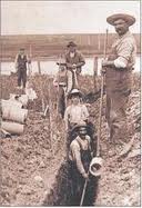
 Our
drain history is more modest compared with the ancient draining experiences
discussed above. We believe the first drain ditches on Ragnabo Farm were made in
the first decades in the 1700's as they can be seen and read about in
documented maps from 1764 and later. Here are a collection of pages in
historical sequence showing the development of drainage system over time
WM
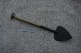
History from 1764 up until Today. The first drains were small and shallow open
type of ditches just enough to drain out the excess surface water. Ditches
were all handmade using shovels and similar tools seen in picture to the left.
In some of the ditches were placed wooden poles or field rocks and were then
refilled with soil to become sub-surfaced drain systems. Over the years there
were patterns of ditches made as the demands for more arable land become higher,
as can be seen in map from 1910 and later. Magenta colored lines in map are larger
ditches while the blue lines are smaller.
Our
drain history is more modest compared with the ancient draining experiences
discussed above. We believe the first drain ditches on Ragnabo Farm were made in
the first decades in the 1700's as they can be seen and read about in
documented maps from 1764 and later. Here are a collection of pages in
historical sequence showing the development of drainage system over time
WM
History from 1764 up until Today. The first drains were small and shallow open
type of ditches just enough to drain out the excess surface water. Ditches
were all handmade using shovels and similar tools seen in picture to the left.
In some of the ditches were placed wooden poles or field rocks and were then
refilled with soil to become sub-surfaced drain systems. Over the years there
were patterns of ditches made as the demands for more arable land become higher,
as can be seen in map from 1910 and later. Magenta colored lines in map are larger
ditches while the blue lines are smaller.
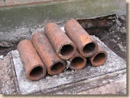 From
the years after 1900 it became a common practice to use ceramic materials in
making tile drains. As an example clayware pipes are shown in picture on the
left. These increased the hydraulic conductivity quite drastically and drain
system could be arranged into regular patterns similar to fish bones as seen in
map from 1946 (cyan color). At the
time they had simple instruments to assist in getting the drains at proper
level. In some cases they probably used the ground water table as an aid in
getting the right depth and choose the timing of the job as best. One can
clearly say farmers were highly skilled in drainage work at the time. Drains
were handmade and followed the surface slope and avoiding surface elevations.
Typically they had to make minor curves to avoid conflicts with larger stones
and rocks. They used clay (if available) or 'fat' top surface soil to seal the
tile joints. Very often the work was very good performed and the drain system
could last for several decades. Eventually drains become clogged with sand and
roots and farmers had to make new ones. One problem that became apparent was
that there was often no map information to hand over to next generation of drain
architects. Farmers were not then helped by earlier digging work. They
simply did not know the architecture of previous water system. Worst case appeared if
new starting point was set at a too high level or they chose too high slope
from the lower point they could not incorporate late discovered earlier drains
into the new ones. In some cases the previous drains were still functioning
which lead to the effect that the farmer fixed one drain problem but created
another drain problem instead. This could become a marsh (wetland) on other parts of the
field.
From
the years after 1900 it became a common practice to use ceramic materials in
making tile drains. As an example clayware pipes are shown in picture on the
left. These increased the hydraulic conductivity quite drastically and drain
system could be arranged into regular patterns similar to fish bones as seen in
map from 1946 (cyan color). At the
time they had simple instruments to assist in getting the drains at proper
level. In some cases they probably used the ground water table as an aid in
getting the right depth and choose the timing of the job as best. One can
clearly say farmers were highly skilled in drainage work at the time. Drains
were handmade and followed the surface slope and avoiding surface elevations.
Typically they had to make minor curves to avoid conflicts with larger stones
and rocks. They used clay (if available) or 'fat' top surface soil to seal the
tile joints. Very often the work was very good performed and the drain system
could last for several decades. Eventually drains become clogged with sand and
roots and farmers had to make new ones. One problem that became apparent was
that there was often no map information to hand over to next generation of drain
architects. Farmers were not then helped by earlier digging work. They
simply did not know the architecture of previous water system. Worst case appeared if
new starting point was set at a too high level or they chose too high slope
from the lower point they could not incorporate late discovered earlier drains
into the new ones. In some cases the previous drains were still functioning
which lead to the effect that the farmer fixed one drain problem but created
another drain problem instead. This could become a marsh (wetland) on other parts of the
field.
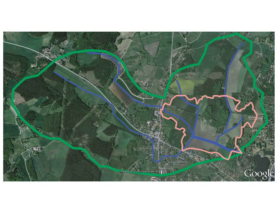 Following
link shows a graphical description of
Ragnabo Rain Catchment Basin (Google Map).
Map shows the rainwater catchment enterprise "Ragnabo Dikningsföretag from the year 1955" as
the inner polygon in pink color. This polygon is defined as the area that has
advantage (in swedish båtnad) of the drainage system. The area size of polygon is 60.7 hectare. Outer green polygon shows the borders of the basin.
The area size of the basin is 3.6 square kilometer (km2).
Following
link shows a graphical description of
Ragnabo Rain Catchment Basin (Google Map).
Map shows the rainwater catchment enterprise "Ragnabo Dikningsföretag from the year 1955" as
the inner polygon in pink color. This polygon is defined as the area that has
advantage (in swedish båtnad) of the drainage system. The area size of polygon is 60.7 hectare. Outer green polygon shows the borders of the basin.
The area size of the basin is 3.6 square kilometer (km2).
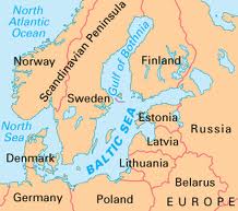
Map
also shows the main water flows within the basin in blue color. The outlet of the basin is
located on the south east of the basin. The outlet is connected to the
Kalmar Strait and the Baltic Sea.
All rain that falls within the basin flows
to the outlet. The capacity of the water lines increases as closer to the
outlet you come. This can be seen by clicking on the icons along the flow lines in map.
Information about dimensions area is given.
Map also
shows 55 sludge wells that catches sand and other debris in the water. By
clicking on icons the building year will be shown. Note that no wells were built
before 1955. Red wells are built between 1955 and 1981. Yellow wells are built
after 1981.
 To
sum up, it is important to have the full picture of the drainage land, both
stone ditches and pipes location and design structure over time, while developing
new drain systems. There is almost not any 'virgin land' (untouched) today where new
drains can be made without consider old systems. However a new systematic
developing of new drain system with small distance in spacing and use of laser
instruments avoids the problem.
To
sum up, it is important to have the full picture of the drainage land, both
stone ditches and pipes location and design structure over time, while developing
new drain systems. There is almost not any 'virgin land' (untouched) today where new
drains can be made without consider old systems. However a new systematic
developing of new drain system with small distance in spacing and use of laser
instruments avoids the problem.