How to implement CDI:
 The existing drainage
system map, if available, is a good start. This map
Controlled Drainage &
Irrigation (Google Map) shows how the CDI technique has been implemented on Ragnabo Farm.
The CDI additions can be
seen as makers in map. They show where suitable places for implementing
control structures can be located. To save cost it is recommended to re-use (if
available) and re-build existing structures such as sludge wells and convert
them into a control structures. Detailed description on CDI as well as result
can be found here (pdf): Agricultural Practices to Prevent Eutrophication.
The existing drainage
system map, if available, is a good start. This map
Controlled Drainage &
Irrigation (Google Map) shows how the CDI technique has been implemented on Ragnabo Farm.
The CDI additions can be
seen as makers in map. They show where suitable places for implementing
control structures can be located. To save cost it is recommended to re-use (if
available) and re-build existing structures such as sludge wells and convert
them into a control structures. Detailed description on CDI as well as result
can be found here (pdf): Agricultural Practices to Prevent Eutrophication.How to decide on location for structure position:
Besides map of the drain system a topology map is also very helpful since control structures should be placed at low elevation points. One should also seek drain node points in map because this will create a large service area for one specific control structure. At the same it is necessary avoid places that will be in conflict with farming transport and machine operations. So in the end it is a compromise, sometimes you even need to move existing node points to field boundary because of practical reasons. In average you can serve about 1.3 ha per control structure, more if very flat land.
Make plan for three-functioning system:
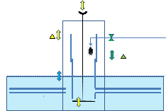 Remember
that the earlier water management architects (our 'farm ancestors') only planned
for 1st. function: the out-drainage function. Now you have to plan for adding
function number 2: To dam up the water. And optionally also plan for adding
function number 3: To irrigate (also called sub-irrigation) the land. All 3
functions can be fulfilled in the same control structure as shown in picture to the left. It saves cost, reduces hardware and
simplifies management. Note that irrigation requires that water is available
during the dry season, either from a pond or a creek.
Remember
that the earlier water management architects (our 'farm ancestors') only planned
for 1st. function: the out-drainage function. Now you have to plan for adding
function number 2: To dam up the water. And optionally also plan for adding
function number 3: To irrigate (also called sub-irrigation) the land. All 3
functions can be fulfilled in the same control structure as shown in picture to the left. It saves cost, reduces hardware and
simplifies management. Note that irrigation requires that water is available
during the dry season, either from a pond or a creek.Map information:
To implement CDI you need fully information of how existing drainage lines are located but also in what condition there are in. If they are not good they have to be replaced or reconditioned. If not known they have to be located. You are helped with the fact that they have not moved after being placed in soil some long time ago, so old maps are a good source for info. If no maps exist then it takes some extra cost to find out. Or you could skip and make a completely new system. It is also advantage if you know how soil surface respond heavy rainfall as well as dry periods. It affects tile drains spacing and depths. Most important is to have full knowledge around the node points. Generally irrigation requires less depth than controlled drainage, for example 50-60 cm. If placed deeper the response time gets to long as you probably need to adjust for possible upcoming heavy rainfall. Watching the daily weather forecast is therefore important.
CDI Results:
 Here are some nutrients balance and
nitrogen leaching results (pdf): CDI results.
Here are some nutrients balance and
nitrogen leaching results (pdf): CDI results.Results shows high effectiveness in using nutrients (=low on surplus nutrients) and low values on nitrogen leaching compared to a similar farm.
 CDI opens up for cost efficient
and low energy sub-irrigation as it can be made automatic and made continuously
operational on 24 ha, 24 hours a day, 7 days a week without any work or moving
of machines. The energy consumption is about 1000 kwh per year for the CDI.
CDI opens up for cost efficient
and low energy sub-irrigation as it can be made automatic and made continuously
operational on 24 ha, 24 hours a day, 7 days a week without any work or moving
of machines. The energy consumption is about 1000 kwh per year for the CDI.